Banff National Park

Popular Rocky Mountaineer Stop

Canada’s Banff National Park is known the world over for its mountain scenery. If you visit the park you will see people from many different countries who are busy enjoying the wonders of the park.

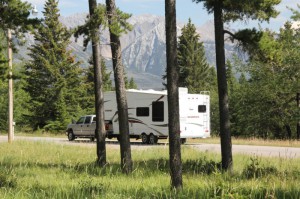
RVers come from all across North America to enjoy the camping and to enjoy the pleasure of driving through the park. This is a place where high grey mountains puncture the deep blue sky with majestic ease. On their sides, glaciers cling to sidewalls, or fill beautiful cirques. Hidden alpine meadows call to hikers to come and explore their quiet domains cloaked with rafts of colourful flowers, the silence broken by the sudden whistle of the marmot,

RV in Tunnel Mountain CG

or the sharp crack of shifting ice in a nearby glacier. Walk around a shoulder of rock and suddenly revealed below might be the immeasurable beauty of a tiny emerald lake, one of the jewels of the mountains of Banff.

The park is huge, at 6,600 square kilometres (2564 sq. miles). Setting aside the land for protection began in 1883 when workers building the Canadian Pacific Railway (CPR) discovered a cave with hot running water. The Banff Upper Hot Springs are now are great place to soak in the natural hot water spring, with the facilities for your comfort just at hand.

Motorhome in Tunnel Mtn. Campground

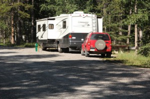
There are campgrounds for everyone. A favourite place to stop is at one of the Tunnel Mountain campsites, just a short distance from the Banff Townsite. If you stop at the Lake Louise campsites you are close to the entrance to Lake Moraine and the Valley of the Ten Peaks which is perhaps the greatest view in the Rockies, and is easily reached.

Lake Moraine, and Lake Louise have become a magnet for every tourist that come to the park and this horde of people is spoiling the beauty of what they had come to see. When I first visited lake Moraine, it was at the end of a long dirt road with a little camping area. Now the road is paved, and there is a huge parking lot, and no camping. Now your experience is fighting for a parking spot, and working through jostling crowds. Try to avoid the summer months, if you want to experience what stirred those who realized what a gem there was here.

Handsome elk on guard duty

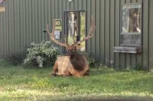
For years visitors had the opportunity to see a herd of buffalo just outside of town, but they were removed. The good news is the buffalo herd may return to the park although they will be placed in a remote back-country, and not up close for viewing as they were formerly. However, they may expand their range if left alone.

Come to the park and enjoy the great scenery. If you can arrange it, avoid the summer months.

Happy RVing!

For more than four decades James Stoness has travelled the roads of North America, photographing and writing about what he has seen. His travel articles and beautiful pictures have been published in several magazines and newspapers. He is also the author of five western novels.  Visit his website at:  www.stonesstravelguides.com

Rails to the Klondike

In the summer of 1896 a prospector named Skookum Jim discovered gold in Rabbit Creek which runs into the Klondike River, in Canada’s Yukon. The claims were registered at a camp called Forty Mile, because it was forty miles from Dawson on the Yukon River.

Tour Train at Skagway

Miners from Forty Mile raced to the new site to make claims for themselves. Word got out but it was the arrival of a steamer in Seattle with a large quantity of gold the set off the gold rush. But it was a couple of years before the mob of prospectors descended along the Klondike River staking claims along 150 km of the river.

Getting there was the major problem. One of the popular routes would see a steamer sailing into the Lynn fjord, commonly called the Lynn Canal although there is nothing about it relating to a canal. They disembarked where the town of Skagway is located. From here

Steam train leaves the Skagway Station

it was necessary to climb through the steep mountain gorge, over White Pass, into Canada. The trail was rough, narrow and extremely dangerous. Pack horses fell from the ledge and died by the thousands, and people perished too from the cold and hunger of the trail.


The Canadian government used the Mounties to enforce the requirement that the prospectors had to carry with them a tonne of supplies to carry them through the winter until they could fend for themselves. However, moving a tonne of supplies up and over the pass meant a lot of trips back and forth, and it was difficult to guard the supplies the burdened men left cached at the other side of the pass.


View along the route.

Entrepreneurs began dreaming of a railroad to carry people and supplies over the pass. Michael Heney, born in Ontario, Canada, teamed with financiers from England to build the impossible, a railway to the stars. Heney’s study of the steep canyon made him realize that a narrow gauge railway was what he needed. A narrow gauge could manage sharper turns than the wider traditional track and the roadbed was cheaper to build. From Skagway the tracks would climb to 900 metres in 30 kilometres with up to 4% grades and 16 degree curves.


Time was of the essence. If they were to capitalize on the traffic to the Klondike gold fields they had to be quick. Gold rushes traditionally did not last very long. Even so, it wasn’t until 1899 that tracks reached Bennet, and by the next year there were tracks into

Remnants of the old trail.

Carcross. Even so, the gold rush was slowing, but the railway carried heavy freight to big mining companies. But the times became worse and the trains stopped in 1982.


The Lynn Fjord’s scenery brought an increasing supply of tourists on cruise ships and in 1988 the White Pass & Yukon Railway opened for business from Skagway to White Pass. Later trains reached Carcross. Passenger traffic reached 360,000 tourists during the 2010 tourist season.

It’s no wonder either. The train is one of the top favourite things to do while in Skagway. The views of the mountains from the train are terrific. The staff are pleasant and willing to explain about things that you are seeing. The sight of the old trail used by the early would-be prospectors brings exciting twinges of the hardships those people endured. The best reason for going, amidst all this history and beauty, is the relaxing ride!

Happy RVing !

This is in one of the tours in ‘Canada: Beyond the Far Horizons’ a Touring North America guide book).

For more than four decades James Stoness has travelled the roads of North America, photographing and writing about what he has seen. His travel articles and beautiful pictures have been published in several magazines and newspapers. He is also the author of five western novels.  Visit his website at:  www.stonesstravelguides.com

The Magnificent Desert

Desert View

More and more of the snowbirds who have been frequenting the coasts of Florida and Texas are spending their winters farther west. They have discovered the beauty of the desert. Low humidity, sunny skies, and long picturesque views have won them over. Of course, winter is the best time to visit the deserts. Temperatures range from cool to comfortably warm. Most crawly creatures are sleeping away their ‘winter’ and the weather is great for visitors to get out and walk among the strange desert vegetation.
One of the very scenic drives is found in eastern California passing from Death Valley NP south through the Mojave Preserve to Joshua Tree NP. It’s a drive filled with a variety of desert scenery.

Desert Dunes
Desert Dunes

The bajada is a feature not observed where there is a lot of vegetation. It is a broad apron of debris accumulated around the cliffs and the resulting view is that of a sea of small mountains surrounded by sloping oceans of sand.
This route roams across desolate flat lands and up and down numerous small mountains. There are always mountains in view and as you approach the tops of the ridges you never know when you will be entranced by a wonderful jumble of blue mountains and hidden valleys where you can see wave upon wave of purple ridges rolling to the horizon.
Normally, we would take this trip south from Furnace Creek, in Death Valley NP but the summer of 2004 arrived with deadly floods that have closed many of the roads in the south of the park. Instead I suggest going west from Las Vegas to Shoshone and heading south from there.
Many highways do not have installed culverts. Instead there is a dip in the road where the water crosses. Most have warning signs that tell you not to enter when water is flowing. You might wonder if water ever flows there but a careful look at the erosion at the end of the dip, or at the sand and stones strewn across the pavement might change your mind. Cars do get carried right off the highway from the force of the water in these flooded dips.

Salt Beds

The Amargosa River drains a vast area to the east and eventually the highway crosses the several branches of the river. It’s strange to see so many culverts in a row under the highway with not a drop of water in sight. After the river rounds the southern end of a mountain range it then swings north to drain into Death Valley where it forms a lake for a while, and eventually evaporates leaving the white salt pans that are first to catch the eye of the visitor to the park.
In the Mojave Preserve, a long descent through cacti and creosote bushes takes you to Kelso Station, an old railway station of beautiful Spanish architecture that is the new park

Kelso Depot Visitor Centre

visitor centre for the vast Mojave National Preserve. The nearby Kelso Sand Dunes rise to over 600 feet above the desert floor in a profusion of shapely curves that extend far down the valley. Although difficult to climb it might be worth the effort just to slide down one of the steeper faces, or to listen to the music of the sliding sand.
Eventually, you make another winding climb before rolling down another long slope to Amboy where the flow from an ancient volcanic cinder cone left a streak of black lava across the dry sands toward dry Bristol Lake. On the lake, sand dikes surround evaporation ponds used to collect salt.
For miles the vegetation changes from lowland desert plants to highland varieties and back again as the roller coaster ride continues, taking you to the top of the Granite Mountains where erosion is creating strangely sculptured pillars and scattered piles of massive boulders.

Sunset in Joshua Tree NP

In the town of Twentynine Palms artists have painted beautiful murals with western themes onto the sides of buildings. In nearby Yucca Valley, Hollywood has captured the beauty of the surrounding area on film in ‘It’s a Mad Mad Mad Mad World’.
For more desert scenery head south into Joshua Tree NP which has a fantastic variety of eroded mountains, huge boulders, and a couple of cactus patches.

Happy RVing!

For more than four decades James Stoness has travelled the roads of North America, photographing and writing about what he has seen. His travel articles and beautiful pictures have been published in several magazines and newspapers. He is also the author of five western novels.  Visit his website at:  www.stonesstravelguides.com