Nisga’a Memorial Lava Bed Park

Basalt lava flow covered with mosses and lichens

Volcanoes are not choosy. They erupt wherever they can, and whenever they are ready. Two hundred and fifty years ago a terrible calamity hit the Nass River Valley in British Columbia. A volcano erupted and spewed lava down the hillside into the valley and then flowed northward to burn and bury two villages of the Nisga’a aboriginal tribe. The gases and the lava killed over 2,000 natives. The flow buried some of the original channel of the Nass River and pushed the entire river northward across the valley to its present location.

Today, a 179 square kilometre park is preserved as a memorial to those families who

Cracks in frozen lava flow

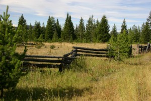
perished. The park is managed together by the aboriginals and the Provincial Government. If you visit you will find a campground with 16 sites, and a colourful Visitor Centre which may have a resident artist on duty during the summer time. There are also maps of the track of the lava flow, and native artefacts.

Solid blocks of lava thrown upward as lava pushed

A guided tour will take you on a trail to the lava cone. The trail is moderately hard so wear good hiking boots for the 4 hour hike which takes you 3 kilometres over the lava to the cone.

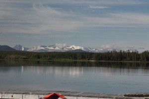
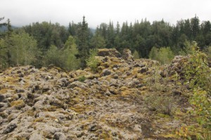
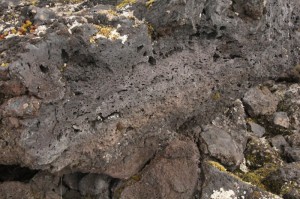
If you travel from Terrace, heading north, you will see Lava Lake. This lake is the result of the lava damming the river. Often the river  now flows under the lava and is out of sight in places. The basalt lava flow is extensive and very interesting to examine as you follow trails across the surface. Normally you would find basalt lava to be very black. In the lava field it has a surface coating of lichens and mosses and looks somewhat tan, or yellow. Do not leave the trail as it destroys this new vegetation which is slowly turning the basalt into soil.

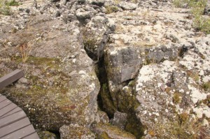
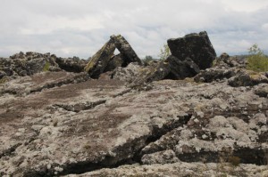
Notice how the surface is often buckled, and heaved up in blocks. This is caused by the lava surface solidifying or freezing, while underneath, the lava was flowing quickly. This is similar to a stream with ice flows. Sometimes the flow would pushNisga’ upward, and blocks of basalt would flow and jam causing even more buckling of the crust. You will see

these areas and realize the tremendous

Hole in frozen lava caused when lava flowed around a living tree, which later rotted.

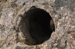
force and pressure required to redesign the landscape in this manner. If you follow Tree Mould Trail you will see several examples of this, and you will see a hole through the rock formed when lava flowed around a live tree and solidified. Later on the tree rotted leaving the round tunnel through the rock. Some blocks whose edges you can see show multiple holes. These were gas bubbles that were trapped in the freezing lava.

Bubbles trapped in frozen basalt lava.

There are also attractive rapids and waterfalls.

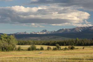
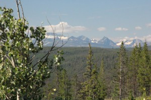
The drive in from Terrace is very scenic with great views of the mountains. Then suddenly you are on top of the lava beds. Take time to go and visit the site of Canada’s last volcanic eruption.


Happy RVing!

For more than four decades James Stoness has travelled the roads of North America, photographing and writing about what he has seen. His travel articles and beautiful pictures have been published in several magazines and newspapers. He is also the author of five western novels.  Visit his website at:  www.stonesstravelguides.com

Exploring the Chilcotin Plateau

Rustic Log Snake Fences

Heading west from Williams Lake, British Columbia, spectacular Highway 20 takes the adventurer across the ever-changing scenery of the Chilcotin Plateau. This plateau fills the space between the Coastal Range and the interior.

A great view.
A great view.

The variation in topography is what makes up the exciting  variety in the scenery.

You may not realize it, but the largest ranch in North America was the Gang Ranch.

Horses on the road
Horses on the road

It had cowboys tending cows over 1,000, 000 acres of the plateau. Several large ranches still operate in the area where seeing old fashioned log snake fences, and herds of cattle and horses will not be that unusual.

The traveller will enjoy the rolling grassland scenery, interspersed by canyons and cliffs. Lakes, streams, and rivers attract the fishermen, canoers, and those who like to sail. Distant whitecapped mountains draw the hikers, and also those who want to spend some time on a long trip into the wilderness on horseback.

View from Escott Bay Resort

If you want to camp, you will find a large number of campgrounds. The resorts attract people who want comfortable accommodations  in rustic areas with great views. Certainly the wilderness ambiance permeates the atmosphere of the entire trip across the plateau. Escott Bay Resort, and Chilcotin Lodge are two, among many, that fit the requirements of a great stay, and also have a few campsites.

Cosy Interior Chilcotin Lodge

As you head west you pass into Tweedsmuir Provincial Park, and drop down a great hill into the Bella Coola valley, and a completely different type of scenery. At Stuie, near the bottom, you will find the Tweedsmuir Park Lodge, famed for its grizzly bear viewing. And in winter, even more famous for its skiing.

The  450 kilometre drive from Williams Lake to Bella Coola has long been part of one of British Columbia’s most popular scenic circle drives. Instead of returning to

Grizzly near Tweedmuir Park Lodge

Williams Lake, drivers would board the ferry at Bella Coola, cross to Vancouver Island and make their way via another ferry to Vancouver.

This circle drive is facing disaster! The BC government is cancelling the ferry, apparently with total disregard to the damage it will do to the tourist accommodations along the Chilcotin route. It’s difficult to imagine how a government could spend so much money promoting tourism and with a single act, destroy everything it had built.

Big Trees in the Valley

No matter what they do, they cannot destroy the experience of a visit to the Chilcotin, although they can make it a great deal more difficult.

Happy RVing !

For more than four decades James Stoness has travelled the roads of North America, photographing and writing about what he has seen. His travel articles and beautiful pictures have been published in several magazines and newspapers. He is also the author of five western novels.  Visit his website at:  www.stonesstravelguides.com

British Columbia’s Nemiah Valley

West of Williams Lake, British Columbia, there is a remote valley. It is a valley of great beauty backdropped by white crested mountains. This is the Nemiah Valley, the homeland of the Xeni gwet’in (honey gweteen) , one of the six T’silhqot’in bands of aboriginals. The forests broken occasionally

White tipped mountains add to the beauty of hte Nemiah Valley.

by sparkling lakes, and rivers, have been providing food, and medicine to these people for hundreds of years. Their traditional food has been salmon, moose, and deer meat. Their vegetables were the wild potato, balsam root, and other plants they learned to eat, and some of them they used for medicine.
In 1994, the government created Ts’yl?os Provincial Park, a large protected area of over 233,000 hectares, to protect the land

Pole Snake fence.
Pole Snake fence.

around Chilko Lake. Chilko Lake is the highest fresh water lake in Canada and is known for it beautiful blue waters and the two mountain ranges that close it in. the lake is more than 60 kilometres long and narrow, making it a prime target for high winds moving down the lake. It can quickly go from peaceful, to having 5 foot high waves and is not a lake for novice boaters. Its steep shoreline makes it difficult to get of the off water for shelter from the winds.

Konni Lake Campground area en route to the Provincial Park.

You access the valley over a long, sometimes rough, gravel road, and drive for long distances surrounded by forests of aspen, poplar, and evergreens with few places for long views. Once you are down in the valley you start to see the white tipped mountains in the distance flanked by endless green forests.
There are a few cattle ranches along the way, and in many places you will see the traditional pole snake fence. This is an

Horse herd blocks road.

fairly easy fence to construct as it uses the tree trunks intact, and laid end to end.
You may glimpse herds of the wild horses that still roam the Chilcotin Plateau. Or you may see roaming herds of horses from a nearby ranch.
The Taseko River you cross will be quite wild, and turbulent, and grey in colour, because of the silt from the glaciers on the mountains. The white colour is often called ‘glacial milk’. There is a small campground at Konni Lake, not too far from the administration area, with a great view.
If you want to get away from the pavement and enjoy a quiet day or two, you will find it here.

Happy RVing!
For more than four decades James Stoness has travelled the roads of North America, photographing and writing about what he has seen. His travel articles and beautiful pictures have been published in several magazines and newspapers. He is also the author of five western novels. Visit his website at: www.stonesstravelguides.com